Geoinformation technology: studies, training Overview of offers and providers

to providers
(1)
Infos, tips & tests Video stories
(1)

Are you looking for a degree course in geoinformation technology? - Here you will find suitable schools as well as further information, tips and resources for further education.

Would you like personal advice? Contact the provider of your choice via the "Free information on the topic..." button - without obligation, quickly and easily.

Download checklists

Checklist «Finding the right further training» » download here

Checklist «Choosing the right school» » download here

Tipps und Entscheidungshilfen für die Ausbildungswahl

Have you successfully completed your bachelor's degree in geomatics, computer science, cartography or environmental sciences and are you still highly motivated to continue your education? Are you interested in geoinformation and spatial phenomena? Then specialize in geomatics and geoinformation with the Master's degree course in Geoinformation Technology and work with state-of-the-art measurement and information collection technologies in the future. During the three-semester full-time course or the slightly longer part-time course, you will be trained to become an expert engineer who deals competently with the acquisition, processing, evaluation and analysis of spatial phenomena and geoinformation.

Your career prospects as a specialist in the field of geoinformation technology are varied and challenging. You can apply your know-how and expert knowledge in areas such as archaeology, logistics, security or research and use your knowledge in a success-oriented manner. Pursue your professional career and complete the scientifically sound and practice-oriented Master's degree course in Geoinformation Technology.


Questions and answers

Der Masterstudiengang in Engineering mit Schwerpunkt Geoinformationstechnologie richtet sich an motivierte Bachelorabsolventen mit guten bis sehr guten Leistungen in Informatik, Geomatik, Umweltwissenschaften oder Kartographie. Auch Personen mit gleichwertigem Abschluss können zum Studium zugelassen werden.

Im Vollzeitstudium hat das Masterstudium in Geoinformationstechnologie eine Dauer von drei Semestern, im Teilzeitstudium verlängert sich die Dauer des Studiums entsprechend.

Nach Bestandenem Masterstudium in Geoinformationstechnologie erlangen Sie den Titel „Master of Science FH in Engineering mit Vertiefung in Geomatics“.

Der Master of Science in Engineering (MSE) in der Vertiefungsrichtung Geoinformationstechnologie wird ausschliesslich von der Fachhochschule Nordwestschweiz angeboten. Darüber hinaus finden Theorie- und Kontextmodule, die etwa ein Drittel der Studienzeit ausmachen, an den Standorten Zürich, Bern, Lausanne oder Lugano statt und werden für Studierende der MSE aller Fachrichtungen angeboten.

Der Master of Science in Engineering (MSE) mit der Fachvertiefung, der Master Research Unit (MRU), Geoinformationstechnologie umfasst fünf zentrale Theorie- und Kontextmodule, ein Blockmodul, Veranstaltungen und Projektarbeiten zur fachlichen Vertiefung sowie eine Master-Thesis. Das einwöchige Blockmodul im dritten Semester sowie die Theoriemodule und Kontextmodule in den ersten zwei Semestern finden an vier zentralen Standorten in der Schweiz statt, die Module der fachlichen Vertiefung ausschliesslich an der Fachhochschule Nordwestschweiz in Muttenz. In Vorlesungen, Seminaren und Kolloquien werden dabei das fachliche Wissen und Spezialkenntnisse vertieft und im ersten und zweiten Semester an einem Tag in der Woche angeboten. Themen des ersten Semesters sind Spatio-Temporal Data Modelling (semantisch-räumlich-temporal) sowie Geosensoren; Themen des zweiten Semesters sind Geo-Visualisierung und Multimedia-Kartographie sowie Geo-Analyse und mobile Geo-Information (mit Wayfinding / Routing). Hinzu kommen Vertiefungsprojekte zu unterschiedlichen Themen, etwa Geomarketing, 3D City Modelling oder Geodateninfrastrukturen im ersten Semester mit einem Tag pro Woche sowie Web-Geo-Visualisierung, Mobile Mapping oder 3D LBS im zweiten Semester an zwei Wochentagen. Im dritten Semester wird ein praxis-orientiertes Forschungsprojekt durchgeführt sowie die Masterthesis erstellt. Hinzu kommen die zentralen Module.


Aktuelle Forschungsschwerpunkte des Masterstudiums in Geoinformationstechnologie sind derzeit (2016) 3D-Geosensork; Mobile Mapping; Kollaborative visuelle Globen and mixed Reality; Geospatial Imaging;, Geoanalyse und Geomarketing; Mikrodrohnen zur Fern-Erkundung und weitere. Für nähere Informationen wenden Sie sich über das Kontaktformular bitte direkt an die FHNW.


Redaktionelle Leitung:

Stefan Schmidlin, Bildungsberatung, Content-Team Modula AG

Quellen

Website des Schweizerischen Sekretariats für Bildung, Forschung und Innovation SBFI , Website www.berufsberatung.ch (offizielles schweizerisches Informationsportal der Studien-, Berufs- und Laufbahnberatung) sowie Websites und anderweitige Informationen der Berufsverbände und Bildungsanbieter.


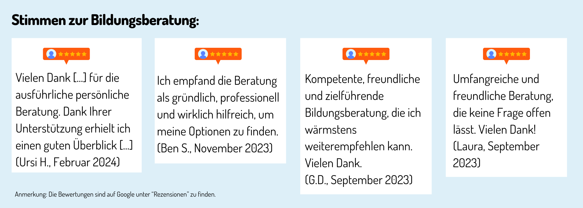
Erfahrungen, Bewertungen und Meinungen zur Ausbildung / Weiterbildung

Preview of the video «4 Schritte zur richtigen Weiterbildung»

Haven't found the right training or further education yet? Benefit from educational advice now!

Further training is not only important in order to maintain or increase professional attractiveness, investing in training or further training is still the most efficient way to increase the chances of a pay rise.

The Swiss education system offers a wide range of individual training and further education opportunities - depending on your personal level of education, professional experience and educational goals.

Choosing the right educational offer is not easy for many prospective students.

Which training and further education is the right one for my path?

Our education advisory team will guide you through the "education jungle", providing specific input and relevant background information to help you choose the right offer.

Your advantages:

You will receive

  • Suggestions for suitable courses, seminars or training programs based on the information you provide in the questionnaire
  • An overview of the different levels and types of education
  • Information about the Swiss education system

We offer our educational counseling in the following languages on request: French, Italian, English

Register now and concretize your training plans.


Sofort zur richtigen Weiterbildung

Address:
Hofackerstr. 30
4132 Muttenz
FHNW School of Architecture, Civil Engineering and Geomatics
The School of Architecture, Civil Engineering and Geomatics is a department of the University of Applied Sciences and Arts Northwestern Switzerland FHNW, based in Muttenz near Basel. It consists of five institutes: Architecture, Civil Engineering, Digital Construction, Geomatics and Sustainability and Energy in Construction.
Region: Basel
Sites: Muttenz

Schulen mit zertifizierter Bildungsberatung